Extract Google Maps Photos with MapDataScraper
Table of Contents
Google Maps photos are not just visual navigation aids, they are powerful tools for B2B lead generation. If you are a business owner, you can visually assess potential business partners, identify market trends, or even uncover a competitor’s recent operational changes due to the owner-added imagery.
However, the sheer volume of these photos presents a significant challenge. Manually clicking and downloading thousands of images one by one is an impractical and time-consuming task, making it virtually impossible to harness the full potential of this visual data at scale.
This challenge has led to the rise of automated solutions to meet the demand for efficient data collection. Some specialized data scraping services have been developed, among them are MapDataScaper and Google Maps Photo Scraper which offer an effective way to scrape and download the data even if you don’t have any coding skills.
Importance of Google Maps Photos for B2B Lead Generation
Businesses are constantly seeking new ways to stand out, attract leads, and build trust. While most companies focus on websites and social media presence, surprisingly powerful, yet often underutilized resources are available within Google Maps.
These resources are photos associated with business listings. They are not just decorative but they are a critical component of a robust B2B lead generation strategy, offering B2B insights and boosting visibility.
Google Maps Photos Scraper
Extract public photos from Google listings for research, content analysis, or competitor monitoring. Simple, fast, and automated.
The Power of Visual Data for B2B Insights
Google Maps photos, including both user-contributed and owner-uploaded imagery, provide a rich source of visual data that can be used for various purposes. These images could be used by B2B companies for the following:
- Market Research and Analysis: Google Maps photos can reveal details about a business’s operations, facilities, product displays, and even the general atmosphere.
- Trend Identification: By analyzing photos, businesses can spot emerging trends in different industries or geographic areas. This could include new storefront designs, changes in product offerings, or even shifts in customer foot traffic patterns.
- Targeted Lead Qualification: Visuals can help qualify leads before even making initial contact. A quick glance at a potential client’s Google Maps photos can provide context about their brand identity, their space, or the type of clients they serve.
Boosting Visibility and Trust
Beyond direct analysis, Google Maps photos play a significant role in improving a business’s online presence and fostering trust:
- Enhanced Local SEO: Businesses with high-quality photos on their Google Business Profile (GBP) receive more engagement.
- Building Credibility and Trust: In B2B, trust is very important. Well-chosen and frequently updated photos of a business’ exterior, interior, products, and even team members can build immense credibility.
- Driving Engagement: Visual content is processed by the human brain much faster than text, leading to higher engagement rates.
The Challenge and the Solution
While the importance of Google Maps photos is clear, the sheer volume of data presents a significant challenge. Google Maps photos are invaluable resources that can be studied, analyzed, and used for various purposes.
Manually downloading thousands of photos one by one from countless business listings is an impractical and extremely time-consuming task. The effort required is virtually impossible.
This is where automated solutions come into play due to demand and need. To meet the growing demand for efficient data collection from Google Maps, specialized scraping services have been developed.
These tools are designed to extract large quantities of photos and associated data, transforming what would be an overwhelming manual process into a streamlined and actionable workflow.
Among the leading solutions, tools like MapDataScraper’s Google Maps Photo Scraper offer a powerful way for B2B companies to extract visual data, turning it into a tangible asset for identifying, qualifying, and acquiring new business leads.
Google Maps Photos Scraper
Extract public photos from Google listings for research, content analysis, or competitor monitoring. Simple, fast, and automated.
What is MapDataScraper Google Maps Photo Scraper
MapDataScraper has developed a suite of powerful scraping services designed to extract valuable data efficiently. Among its flagship offerings, is the MapDataScraper Google Maps Scraper, an indispensable tool for anyone looking to utilize the vast visual data available on Google Maps.
It is engineered to extract download links for every photo uploaded to a specific place or business listing on Google Maps. This includes user-contributed images, owner-added visuals, and Street View imagery, providing a complete visual profile of any location.
Kay Advantages of MapDataScraper’s Google Maps Photo Scraper:
- Cloud-Based Efficiency: The entire scraping process runs seamlessly on our own robust cloud servers. This means users don’t need to worry about complex setups, dedicated hardware, or managing software installations.
- No Proxy Needed for the User: A significant hurdle in web scraping is often managing proxies to avoid IP blocking. MapDataScraper handles all proxy requirements internally, ensuring smooth and uninterrupted data extraction without any proxy setup needed from the user’s end.
- Bypassing Google Limits: Google implements various rate limits to prevent excessive data requests. MapDataScraper’s sophisticated infrastructure, including its proprietary proxy networks, is specifically designed to circumvent these limits, allowing for efficient and large-scale scraping of photos without limitations.
- Exceptional Ease of Use: With its powerful capabilities, the service is also remarkably user-friendly. You can initiate scraping tasks even for those with minimal technical expertise.
Step 2: Creating Tasks and Setting Parameters
Once you log in, proceed to the Google Maps Photo Scraper dashboard it is now possible for you to extract photos from all businesses in a category.
When the “Plain queries option is activated, it is possible to scrape directly over place links. Both methods worked easily and it is very easy to set the parameters.
How to Scrape Photos from Places with Categories
Google Maps Photos Scraper
Extract public photos from Google listings for research, content analysis, or competitor monitoring. Simple, fast, and automated.
Choose Business Category
If you want to scrape photos using the Categories option, you need to select the business categories in the drop-down list. You can select the target category from the list. The category list is compiled from Google Maps and all Google Maps Categories is available online.
Select Locations
Locations are presented to users as a ready-made list and all you have to do is to select all countries and cities from the list of locations. You can also use the “Custom Locations” option that can be used to scrape a custom area. You can also use ZIP codes to scan and scrape deeply in densely populated areas.
How to Scrape Photos from Places With Links and IDs
Aside from simply using the Categories option, the most basic reason to create a photo scraping task with a location link and Place ID is to scrape the desired number of photos directly from a place.
Google Maps link can be used directly as a query. Just copy and paste the link. Apart from the link, you can use Google and Places IDs or search queries with the combination of category + City/ZIP + Country.
Google Maps Photos Scraper
Extract public photos from Google listings for research, content analysis, or competitor monitoring. Simple, fast, and automated.
Photos Limit Per One Place
This particular parameter helps you determine how many photos will be scraped from each place/business in the category. If you want to scrape all photos from all places, you can enter a big number. With this strategy, the download links of all photos are extracted without limitations.
Places Per One Query Search
This specifies the limit of organizations to take from one query search.
When you are using the query to find a specific place (e.g. ‘Central Park NY US’) you probably want to use ‘1’ to get the first place (just in case Google will find something else). However, when you are searching for ‘restaurants, NY, USA’ you might want to extract all the places from your search and use ‘500’.
There are no more than 500 places per one query search on Google Maps. For densely populated areas you might want to split your query into subqueries to get all the places inside. (e.g. ‘restaurants, Brooklyn 11211’, ‘restaurants, Brooklyn, 11215’).
Filtering (Only Available for Premium Users)
This feature will give you access to a broader range of records, offering deeper, more comprehensive insights.
Google Maps Photos Scraper
Extract public photos from Google listings for research, content analysis, or competitor monitoring. Simple, fast, and automated.
Other Parameters
This parameter will enable you to choose the results extension you want to use such as XLSX, CSV, JSON, and Parquet. The Task tags will enable you to label the task to find it later in the tasks page.
Step 3: Start Scraping by clicking ‘Get Data’ and confirm the task after reviewing all the parameters.
The task will then be sent to the Tasks Page so that you can track the progress of all the tasks.
Step 4: Download Your Result File, Review and Analyze the Data
You can download your result files anytime you want on the Tasks Page. But it’s important to note that all results are only stored for 30 days on our servers.
Review and analyze the downloaded scraped data on any spreadsheet viewer you used. Each scraped data can be checked in sequenced columns in the result file.
Specific Use Cases of Google Maps Photos and Examples (Beyond Lead Generation)
- Competitive Analysis by tracking store renovation, new branding, monitoring product displays, identify operational changes and uncovering potential supplier or partners.
- Franchise Expansion/Site Selection.
- Product Placement/Merchandising Analysis.
- Identifying Niche Markets
- Auditing and Compliance for multi-location businesses.
- Real Estate Investment.
Google Maps Photos Scraper
Extract public photos from Google listings for research, content analysis, or competitor monitoring. Simple, fast, and automated.
Specific Use Cases of Google Maps Photos and Examples (Beyond Lead Generation)
- Competitive Analysis by tracking store renovation, new branding, monitoring product displays, identify operational changes, and uncovering potential suppliers or partners.
- Franchise Expansion/Site Selection.
- Product Placement/Merchandising Analysis.
- Identifying Niche Markets
- Auditing and Compliance for multi-location businesses.
- Real Estate Investment.
Ethical Considerations and Best Practices for Data Scraping
While the power of Google Maps Photo Scraping is undeniable, it’s essential to approach this practice with a strong understanding of ethical considerations and legal responsibilities.
Responsible data collection not only protects your business from potential legal issues but also upholds data privacy standards.
- Understanding Google’s Terms of Service: Users are responsible for reviewing and understanding Google’s current ToS, even when using specialized scraping tools.
- Fair Use and Responsible Scraping: Scrape data for legitimate, transformative purposes (e.g., market analysis), not just republishing.
- Privacy Concerns: While photos are public, avoid using them to identify or profile individuals (e.g., faces).
- Data Usage Guidelines and Legal Compliance: Comply with all relevant data privacy laws (e.g., GDPR, CCPA, Philippines Data Privacy Act of 2012).
Google Maps Photos Scraper
Extract public photos from Google listings for research, content analysis, or competitor monitoring. Simple, fast, and automated.
Data Organization and Analysis Tips (Post-Scraping)
Extracting photos from Google Maps is just the first step. To truly harness the downloaded data for effective B2B lead generation and market insights, you need a robust strategy for organizing, analyzing, and integrating this visual data.
- Structure your scraped data into a clean, tabular format so that it will be easy to identify essential columns such as “Place Name, “Place ID,” “Photo URL,” “Category,”, and “Location.”
- Choose the right tools for analysis and link the downloaded data to your CRM of choice.
- Link Visual Data with other sources using a common identifier like “Google Maps Place ID.” This creates a holistic view of combining photo insights with data from company websites, LinkedIn profiles, CRM systems, public business directories, and local demographic data.
Conclusion
Google Maps Photos are packed with clues about businesses, offering insights for B2B lead generation, market analysis, what businesses look like, or what they’re selling. But let’s be real, you can’t just click and save thousands of images one by one. It’s impossible.
That’s why tools like MapDataScraper’s Google Maps Photo Scraper exist. It’s built to do the heavy lifting for you, quickly grabbing all those important photos. It works online, handling all the technical stuff, and even bypasses Google’s limits, so you don’t have to worry about a thing.
This means you can easily get the visual info you need to spot trends, find qualified leads, and really boost your business’s online presence.
Ready to See Your Business Grow?
Don’t let valuable opportunities pass you by. If you want to find new customers and get a clearer picture of your market, it’s time to put these powerful visuals to work.
Use MapDataScraper today and see how simple it is to turn Google Maps photos into real growth for your business.
Start Scraping Today
Join hundreds of professionals using MapDataScraper to uncover new opportunities and grow their businesses.
FAQ
Most frequent questions and answers
A Google Maps Photos Scraper is a tool that automatically extracts photos from Google Maps business listings. It allows you to download images uploaded by businesses and customers for marketing, research, or competitor analysis.
You can scrape and download:
Business profile images
Customer-uploaded photos
Interior and exterior shots
Product and service images
Review-related photos
This helps with content research, competitor monitoring, and market analysis.
The downloaded photos can be used for:
Market research and competitive analysis
Content inspiration and benchmarking
Monitoring visual brand presentation
Creating internal reports and presentations
Archiving visual data for audits
Our tool scrapes publicly available images for research and analysis purposes. However, you are responsible for using downloaded images in compliance with local laws, Google’s terms of service, and copyright policies.
No coding needed! MapDataScraper’s Photos Scraper is fully beginner-friendly. Simply enter the business listing details or search query, run the scraper, and download the images you need — it’s quick, easy, and hassle-free.
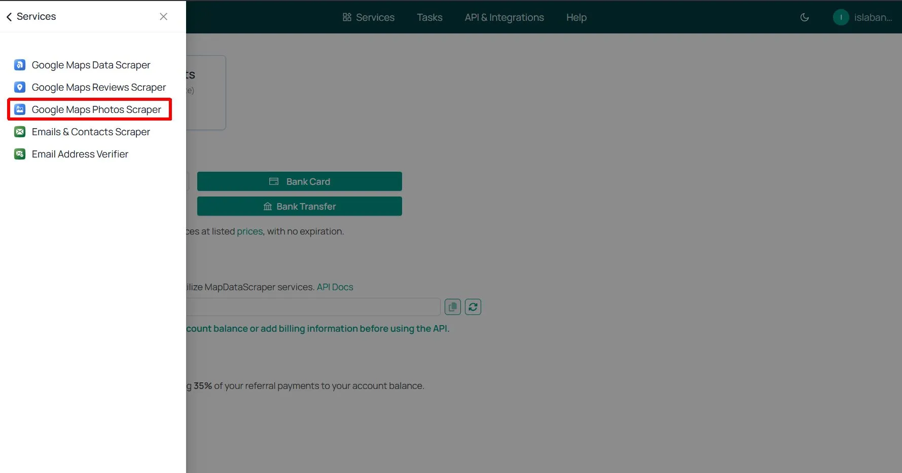
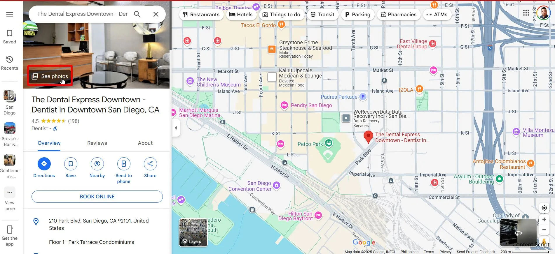
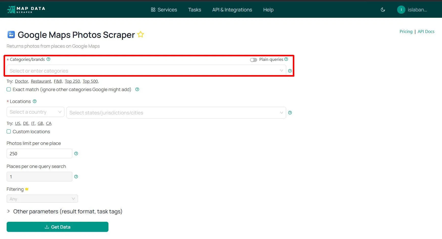
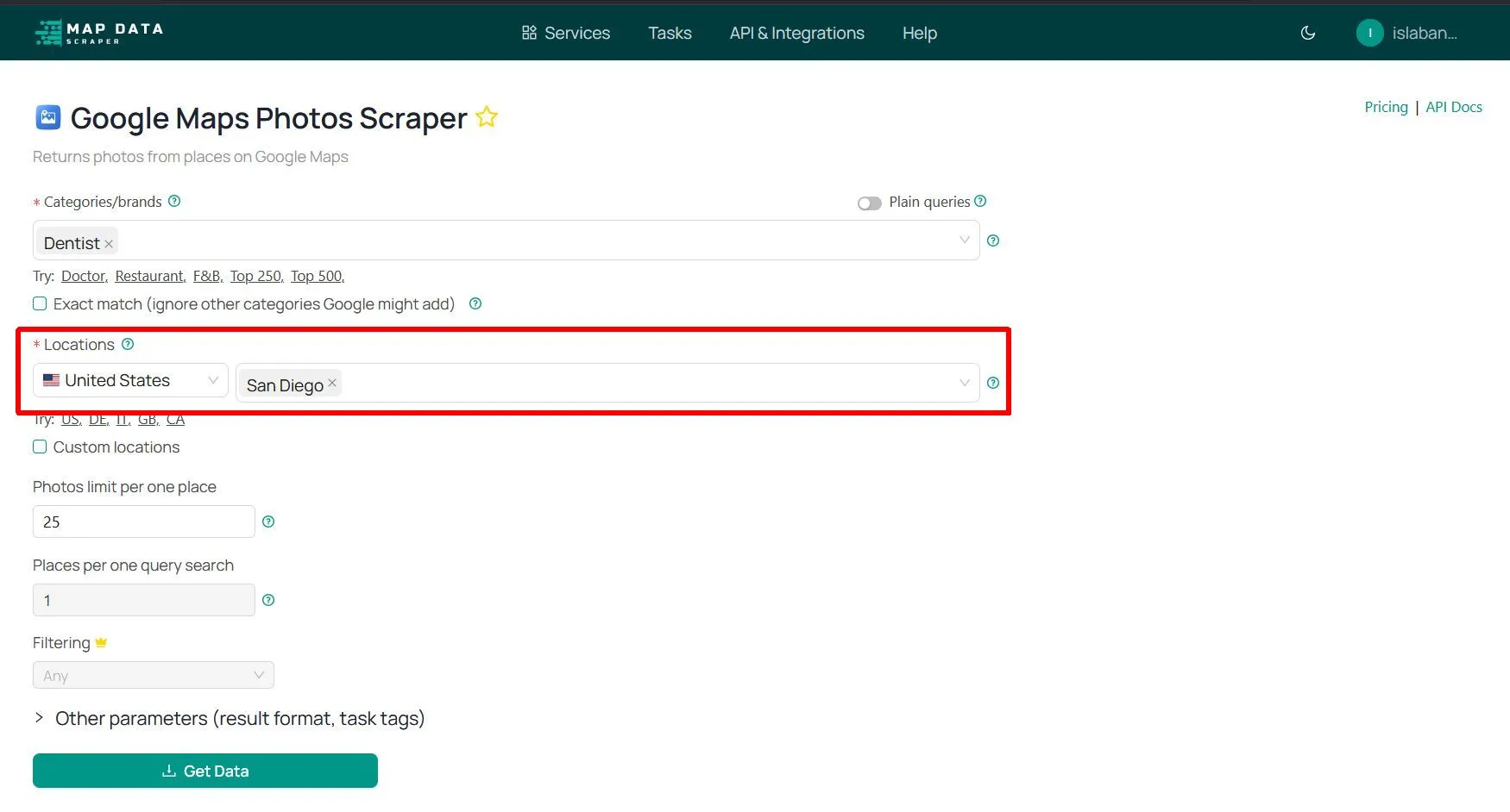
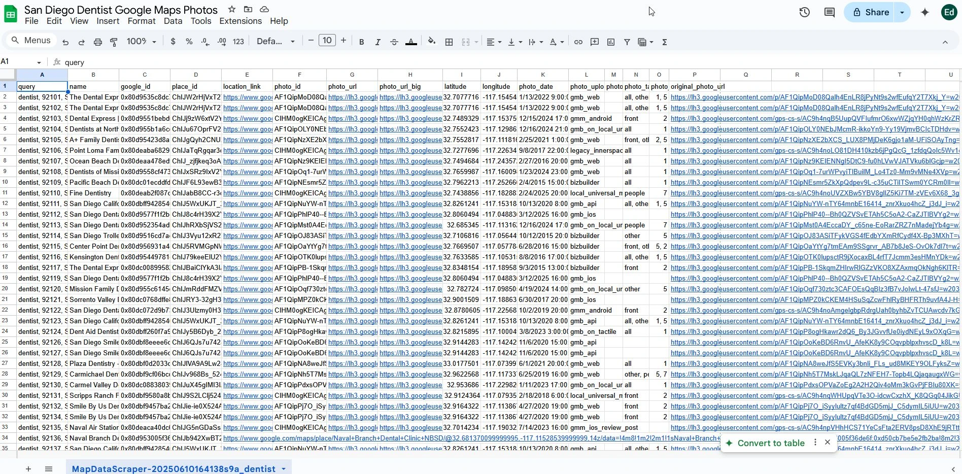
easy to extract business photos, customer-uploaded images, and location visuals — no coding or manual saving needed.
Perfect for marketers, researchers, brand auditors, and location intelligence professionals, our tool lets you download image URLs or actual photo files from multiple listings in just a few clicks. Analyze visual content, monitor brand consistency, or gather location photos for your directories and reports.
With pay-as-you-go pricing and free trial records, you can scrape photos from Google Maps when you need them, without costly software or monthly subscriptions.
Whether you’re managing multi-location brand assets, conducting visual market research, or simply building a business listing database, MapDataScraper makes photo collection easy, reliable, and affordable.